A note on the photos

Most but not all of the pictures on this blog can be clicked though: if you click on them they will take you to a high resolution version on the
SmugMug site of one of the Sons. Use the back button to return to the blog.

Total Pageviews

Index To Posts

Thursday, October 8, 2020

New England Wilderness Walk

September 29 - October 1st 2020 

Calling this a wilderness walk is slightly exaggerated since apart from 5km of creek-walking in the middle the 33km route follows old forest and farm roads, most of which are well-maintained. Moreover, a substantial section is through abandoned farmland - we harvested lemons and strawberries on this trip. But it's a lovely walk with a variety of forest types, and the diversity and abundance of birdlife was truly impressive. As a bonus, it's downhill all the way.

Our trip was fitted into a working week as one member of the party works weekends. We drove the five hours to Bellingen on Monday afternoon, arriving just in time for a good dinner at the Diggers Tavern and settling into the truly beautiful Bellingen YHA (aka The Belfry).

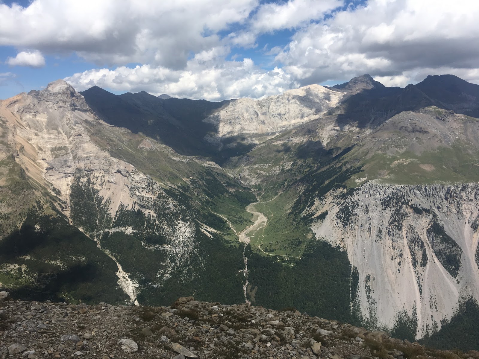
We awoke to a perfect blue sky, and perfect view across the Bellinger River valley to the Dorrigo Plateau,  skeins of mist rising from the river and surrounding forest. As we sat in the garden waiting for the 7am opening of the nearby bakery a pair of Green Catbirds flew in to take a quick drink from a Buddha's head fountain. While often heard in the bush around Sydney, somewhere between a caterwauling tomcat and a crying baby, these bowerbird relatives are rarely seen. But here they seemed perfectly unconcerned by our presence.


Excellent coffee and croissants at the Hearth Fire bakery, and purchase of two loaves for the trip, was followed by a gear inspection. This revealed we were short one tent - a basic error. Calls to local acquaintances failed to raise a substitute, so we were forced to make a detour to Coffs Harbour where Anaconda had a serviceable little dome tent for $53! As a result of this unforced error, and the already 1.5 hour drive to the start of the walk, it was 11.45am when we finally left the car near Point Lookout and headed down Robinson's Knob fire trail.


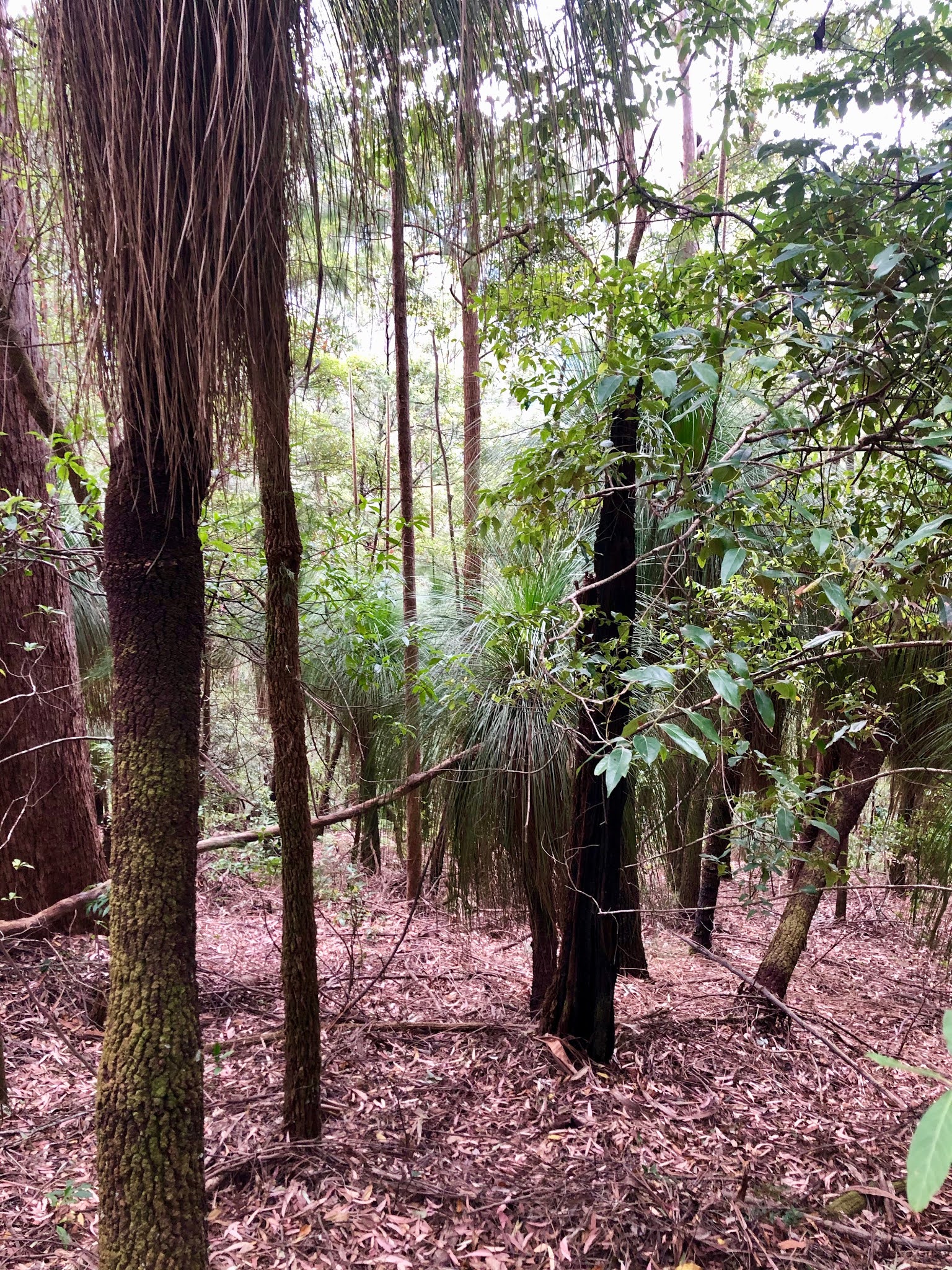
The walk starts at 1350m, high on the New England Tablelands and in the first few hours it drops 1100m to the headwaters of the Bellinger River. We started walking through southern beech forest (Nothofagus) which I was not expecting. After a couple of hours walking steeply downhill on a broad, well-maintained road we turned down Grasstree Ridge vegetated by groves of Xanthhorhea both tall and low, a disused road running for 8km past an old mine and onwards to Sunday Creek, a tributary of the Bellinger. The trail is well-named, as there is a dense understory of these particularly beautiful grass trees - tall, rarely branching and with a knobbly trunk like a banskia.


The Grasstree Trail is still in remarkably good condition, given how steep it is and that it has not been used for decades. There are no washouts, no landslides, just a few tangles of vine across the road, mainly at the start and finish, and remarkably few fallen trees, so you can make a good pace. But is is certainly steep! Because of this much of the road is cut deeply into the hillside, and it would be very hard to lose even if it were more choked with vegetation. 

Having started so late I promised my companions we would stop at the 700m contour or 5.00pm, whichever came first. We reached the 700m line at 4.30, and set up camp in a saddle between two knolls, with the tents in a row on the flat section of track. We had to be as  economical with water, as it was a dry camp, but we had enough to leave 1/2 litre each for the morning, and after a dinner of tuna couscous and some chocolate we were in bed by 8.30pm.


In the morning we ate scrambled eggs with  magnificent olive sourdough bread from the Hearth Fire bakery, then removed traces of our fire. We had dug a pit in the middle of the track and cleared the leaf litter for a couple of metres. Once the pit of cold ashes was covered with soil there would be little trace of our passing. 


The trail continued much the same as the day before, eventually slipping off the east side of the ridge to descend in a series of bends to Sunday Creek. The campsite at Sunday Creek is very pleasant, with a clear area of soft leaf-litter and a big fire-circle. It would be the obvious place to stop at the end of Day One if you had started at a reasonably hour, and would be about 6 hours from the start point for a group of experienced bushwalkers.


Sunday Creek itself is broad with a bottom of boulders and gravel, soon joined by Platypus Creek to form a more substantial creek, but still broad and shallow and descending very gradually towards the main river. The banks are dense rainforest with plenty of lawyer-vine so the only reasonable option is to walk in the creek, which was reasonably straightforward with only a few thigh-deep wades. 


We had read in a previous trip report that the whole area is a mass of Stinging Tree (gympie-gympie) so one of my companions had packed her full bush regenerator gear of thick gloves, secateurs and folding saw to cut a path through the jungle! None of this saw any use, except the saw for cutting firewood and the loaf of bread! We saw exactly 2 stinging trees in the whole trip, not large specimens and well off the track. However, we saw thousands of tobacco plants (Solanum mauretanium), a common invasive weed that someone could mistake for stinging tree, especially in the paranoid mindset induced after being stung by the real thing! But they are very easy to distinguish once someone has pointed out the difference, and the tobacco plant grows abundantly in disturbed areas around Sydney, so many people are familiar with it. In fact, we were in much more danger from being stung by another Urticaceae species, the European stinging nettle, carried up the river from the abandoned farms by birds and bushwalker's boots. 

 We did, however, have a close encounter with a large and healthy red-bellied black snake, reported by the person closest to it to have smiled at her before disappearing into a tussock of Lomandra.

A couple of kilometres of creek walking brought us to the banks of the Bellinger river where we had lunch. The Bellingen bakery's excellent nutty tasting Rye Loaf with tomato, cheese and the very last of the butter. The road starts a couple of kilometers further downstream, so we crossed to the far bank and cut across the river flats there, and then along the bank on gravel and small boulders, until we picked up Darkwood Road. The rest of the walk simply follows the old road along the river until it becomes open to traffic. In their usual manner the Lands Department have deleted the middle section of the road from the topo maps, but in fact it is still there and clearly still used by National Parks vehicles.   

The next section of the walk was a little disappointing - a well-maintained dirt road with roadside vegetation of invasive weeds - lantana thickets, tobacco plant and so forth. There was some reforestation work evident. 


Like all well-engineered roads this one avoided the river when possible and headed into the hills, snaking up and around the heads of  gullies. We were happy to arrive at the turn off to the first plausible riverside camping area, labelled 'Woods camp' on the map. This was, indeed, an old farm clearing in a bend in the river, but there was no cleared area to camp and the whole area was a mass of brambles, stinging nettles and tobacco plant. On the plus side, there were some lemon trees carrying fruit, which turned out to be the edible, not too sour kind, and  birds love this kind of country with dense cover and abundant food - I immediately saw a Crested Shrike Thrush and a pair of Rufous Whistlers. We found an area of of tangled grass reasonably free of spiky and stingy things to put the tents on and crushed down a path through the nettles to the river bank where we found some a decent spot to spend the evening. Time for a swim.


Next morning it was scrambled eggs again, and rye bread, sadly without butter. Then we set off up and up the hill to walk along Darkwood Road, passing abandoned farm buildings and a work crew busy removing asbestos and demolishing them. This was our warmest day, and in the open country walking in full sun through old, overgrown fields we felt pretty hot. Soon, however, we forded the river once more and the road started to follow the river. This section of the walk was lovely - a green road through shady forest running a few metres above a beautiful, rocky river. It reminded me of some of the low altitude long distance walking tracks in France - a wild river valley amongst the farming country. 


We had arranged for the helpful people at Bellingen Canoe Hire to meet us and drive us back up to the car, and as the meeting time was fast approaching I pushed on ahead of the others and arrived at 1.00. The last point you can drive to on Darkwood Rd is where the road is shown ending on the topographic map. It's easy to see when you arrive - a bridge has been removed leaving only a concrete pier in the middle of the river and after that ford there are properties along the road. My companions followed at their own pace stopping for one last afternoon tea break and managing to disturb a few more juvenile brown snakes from sunning themselves on the track, and when I got back with the car at 5.00 I found them sitting in camping chairs drinking tea and eating Arnotts Shortbread biscuits - they had been befriended by one of the local property owners. All that remained was to drive back to the YHA for a shower and another fine meal at the Diggers Arms.


Next morning we awoke to another brilliant blue day and brilliant view, and fortified with first-rate coffee and pastries from Hearth Fire it was time to head home. We had conquered the New England Wilderness Walk and lived to trek another day.


Wednesday, September 6, 2017

Pyrenean Trek Part 2: Aragon

Back to Part I: Béarn

After saying good bye to Hugh in Gavarnie I headed over the border to Spain. For the rest of my trip I was in the Aragonese Pyrenees, which are absolutely spectacular.
Brêche de Roland from about 200m below the pass.

Pyrenean Trek Day 12
Breakfast on a perfect morning camped just below the Brêche de Roland - 3C and no wind. I crawled the last 250m up to the Brêche with far too much in my bag - about 17kg I think - and then hid it behind a rock and walked up Le Taillon (3144m) with a few essentials. There were lots of other walkers  as it was Saturday and there is a carpark at 2200m making Le Taillon a popular day trip. I was feeling strangely weak, with everything taking far too much effort, but nevertheless was back at the Brêche by 12.30 so decided to head on to Refugio de Goriz, as it is only a few km and mostly downhill. The landscape is very barren, with sublime views of the peaks and the Ordessa Canyon. I was really feeling poorly and took a lot of breaks, but nevertheless was at Goriz by 4.30.


The view into Spain from the Brêche

Le Doigt (digit) - a rock pinncle on the way to Le Taillon

On top of Le Taillon, 3144m

Spanish side of the Brêche de Roland from the Le Taillon track

A section of the Spanish track with chains to hold.
The Brêche, Doigt and Le Taillon seen from Spain

View from inside the Caves de Castaret

Collada de Milares

Track to Góriz
There were masses of locals camped around the Refuge de Góriz on Saturday evening ready to climb Monte Perdido in the morning. After pitching my tent I washed and dried the day's clothes using famous  the drybag washing machine, had a fine meal at the refuge (so many people they had to do two sittings), read a couple of chapters of a novel, and fell asleep hoping to feel better in the morning.

Supplies arrive by helicopter at Refugio de Góriz

Pyrenean Trek Day 13
Woke up feeling rested but still not well and also peeing blood. Not good. I flattered myself I had just walked very hard the last two days, but realistically it was probably an infection and explained why I felt so weak the day before. I was either going to get worse or better, and Refugio Góriz, which is only supplied by helicopter, seemed a bad place to get worse so I decided to stick to the plan and walk to Refugio Pineta, which is on a road. I was glad I did, as this was one of the finest days of mountain walking I have done. I had a brutal purge of my pack the night before, discarding four days food and everything I had not used so far, which I reckon got it down from 17kg to about 15kg and made all the difference as far as the feel of the pack went. I walked slowly to the col and then up the slopes of Punta las Solas to 2700m, about 500m above Góriz. I had decided to follow the more spectacular 'old' GR11 rather than the new, lower route created to make this section safe in snow and bad weather. This route goes around the edge of the mountain just below the peak on a series of ledges. The hairy bits are provided with chains to hang on to. I had spectacularly good weather, so it was actually an easy walk - I was cursing a bit when I got to the turn to the summit - if I had been feeling better it was so close!

Looking back towards Góriz


Murrion de Arrablo

Gorgeous stream on slopes of Punta las Solas - someone was camping here

Taken by a French walker I met


Not what urine is supposed to look like - the Emperor Heliogabalus would have enjoyed this photo

The old GR11 runs along the big ledge and over the white rocks, where there are chains to hold on to


Rio Bellos valley, where the new GR11 track runs
The old GR11 drops to 2450m to rejoin the new path at Collata d'Añisclo, which then drops to a Refuge a mere 1240m at the very bottom of the stunningly beautiful Valle de Pineta. The last part was steep - 1200 vertical meters down the slope you can see in the photos! I stopped for an hour on a particularly beautiful pinnacle and made tea to admire the view. This valley really is a stunner. Arriving at the Refuge I was surprised to find both that camping is banned and that they had vacancies. Nice dorms, a hot shower, and a fine meal!

Valle de Pineta
This tea break was one of the highlights of the trip
 
Refugio de Pineta - excellent and friendly

Pyrennean Trek Day 14
I had a very pleasant evening at Refugio Pineta. People are assigned to tables by the staff at each refuge, and table mates always seem willing to talk in whatever shared languages are available. There are many hiking stories to exchange. I explained the idea of long service leave over dinner and the Spanish now all want to work in Australia! Being supplied by road this refuge was even cheaper than usual - 33€ for a bed, breakfast and a four-course meal of salad, pasta, sausage and chips (egg and chips for vegetarians, chips and chips for the German vegan who was the only other foreigner), and yogurt for desert. In the morning I was still peeing blood, so walked down the valley to the nearest village. A lovely walk on tracks through the forest to the picturesque village of Bielsa. People are amazingly helpful here and a local woman who spoke English helped me call and get in the queue to see the doctor who comes for a few hours most days from the nearest town. he prescribed some mild antibiotics and suggested staying there for 48hrs to see if they solve the problem. After a magnificent lunch in the village square I  pitched my tent at a campsite just outside the village.

Looking back up Vallee de Pineta

Bielsa
Pyrenean Trek Day 15
Not much trekking today! Waiting for the antibiotics to do their work and watching local celebrations of the feast of the assumption of the Virgin. Much like an English village fete, but with beer instead of tea!

Festivities in Bielsa
Pyrenean Trek Day 16
Back on the road. I walked from Bielsa up to Parzan to rejoin the GR11. Parzan does not have the historic buildings of Bielsa because it was razed in 1938 just before the fascist victory in the Civil War. Republican troops fought a rearguard action in this valley to give local smugglers time to get refugees over the mountains to France. I am not sure if the village was destroyed in a battle or later when the fascists were 'disrupting the people smugglers business model'. After a last espresso and 'Madalena' in Parzan I trudged 1000m up a dirt road past a hydro power station and camped at 2100m in a pretty valley just below the Collada Urdiceto.


A lovely campsite
with ensuite bathroom


Pyrenean Trek Day 17
A short day over the Collada Urdiceto (or Los Caballos on another map) and down to Biados. I got in to camp very early - 2.30 - and after washing the day's clothes spent the whole afternoon lying in the shade reading Stendhal, which was very pleasant. Unfortunately I had started peeing blood again and was feeling ridiculously weak the last couple of hours of the walk. Felt much better the day before, but clearly those antibiotics in Bielsa did not really deal with the problem. So it seemed sensible to head off again and find a doctor.
Pica de Posets from Biados - 3300m and the second highest peak in the Pyrenees

Pyrenean Trek Day 18.
To catch a bus from Biados I would have had to walk 12km and wait another night, so I paid the local 4WD tour guy 66 euros for a lift to La Fortunada, where there is an 'emergencia'. This turned out not to be a hospital emergency room, but the headquarters of the local rural health service, where I saw the same doctor again and was prescribed stronger antibiotics and advice to stay put for 72hrs and go to a real hospital if I was still bleeding. Then I shelled out another 22 euros for a taxi to Ainsa, where there was a pharmacy to fill my prescription. So I was just a tourist in High Aragon for the next few days. The plus side is that I got to come down the whole of the Valle de Chistau, which is an amazing series of limestone gorges. At one point, we were one one of those uniquely European mountain roads, part clinging to the cliff and part tunnels, when the sky was full of Griffin Vultures (2.5m wingspan) and I realized they were nesting on the other side of the gorge, at the same level, no more than 200m away - sitting happily by their nests watching the traffic. I learned later than there are Lammergeier nests there too - the largest European vulture.

Pyrenean Trek Day 19. 
I came to Ainsa for a pharmacy and a campsite, but found a beautifully preserved medieval hilltown where people gather at dusk on the battlements of the castle to watch sunset behind the high Pyrenees. I joined the throng for dinner in the main square at the usual, late hour here. Restaurants all around the square and the excellent Spanish childcare system of having them run around in little packs in the middle of the square until midnight while their parents eat, talk and stroll with pushchairs.

Sunset on the mountains

Ainsa

Ainsa from my campsite in the morning

Pyrenean 'Trek' Day 20
A lazy Sunday in Ainsa with my only task being to take my medicine! Reading and sleeping in the sun. Another nice sunset from the battlements, after visiting the eco-museum in the old town. They have a collection of sick and injured raptors who for various reasons cannot be returned to the wild, including a Bearded Vulture (Lammergeier, wingspan 250-270cm). Their aviaries are in a roofless part of the castle and they very well-cared for, but this bird was perched at one of the old stone windows looking at the mountains with his red eye and I could not help thinking of the Count of Monte Cristo in his cell. 


Sunset on Monte Perdido, from Ainsa
Pyrenean Trek Day 21
No symptoms, so I headed back to the mountains, to Banosque using local buses. This was slow, but cost 12€ for 150km and was fun. I had two hours in Barbastro waiting for a connection. It is very much a working town, but with a nice historic centre and the a rather ramshackle cathedral whose campanile had SIX storks nests at the top, one occupied by a stork. The road to Banosque is spectacular - at one point they have basically put the road up a slot canyon, with tunnels where there is no room for both road and river.

Barbastro bus station

Barbastro main square

Pyrennean Trek Day 22
To see if the antibiotics had really worked I climbed to the col that I need to cross to return to France and down again. No bleeding, so I was walk back across the mountains. A much nicer way to finish the trip than a bus to Barcelona! Then I spent a second night in Benasque, which is very much a tourist town. There is a pretty old village at its heart, surrounded by a sort of ring road and concentric circles of hotels and apartments, for the ski season, I guess. Fortunately these are almost all decent pastiches of the old buildings, built in stone and slate with wooden windows and balconies. There are about a dozen outdoor stores with all the latest gear and fashions, and an extraordinary number of restaurants. Everyone here is on holiday, in contrast to the other Aragonese villages of recent days - no old men sitting in the playa mayor all day looking sceptical!

A house in benasque

Another house in Benasque

The Maladeta Massif, including Pico de Aneto (3404m the highest in the Pyrenees) and the Valle de Benasque


Porte de Venasque, cut in the crest of the range as a customs post in the 1600s.
Pyrenean Trek Day 23. 
Back through Porte de Venasque with a side trip to climb Pic de Sauvegarde (2738), a popular day walk from Benasque. There were several Griffon Vultures circling the peak. Then I camped by the Refuge de Venasque.  I would not bother with camping gear if I did this trip again, as it is heavy and all you really need is a sheet sleeping bag, since the Refuges have mattresses and blankets, but since I was carrying all the gear , camping by the refuge was the best option unless the weather is dreadful, as the sleeping quarters are cramped and you can still get the meals and use facilities.

Griffon Vulture - 2.5m wingspan

View back to Spain

View into France

Three weeks of beard

Porte de Venasque

Refuge de Venasque


View from my tent

Pyrenean Trek Day 24
Some thunderstorms came through last night, one just before an excellent dinner at the Refuge, followed by a good rainbow, and another just as I went to bed. Did not get a lot of sleep as the wind battered the tent most of the night! This morning was bright and clear but so windy that the tent was dry after breakfast. I spent the day exploring the alpine lakes and minor peaks around the refuge, including a windy walk along the crest that divides France and Spain. Saw what will probably be my last marmots and Griffin Vultures and a Black Redstart. But my best memory of today will be the lovely guardian of the Refuge, who lives in room the size of a shoebox with his wife and two toddlers, running frantically towards the lake with a four-year old under one arm in pursuit of an escaped plastic bag


Boum (lake) de Venasque


Pyrenean Trek Day 25
And so it ended. An 850m descent to Hospice de France followed by a 12km road bash to the 19th century spa town of Bagnères de Luchon.

Looking back to Porte de Venasque


Naturally, the Mairie at Luchon put on fireworks for the end of my hike. Some locals thought it was for the Fête des Fleurs, but I put them straight.


Highlights of this trip:
* Climbing Pic du Midi d'Ossau
* The evening at Refuge D'Arremoulit - alpine lake, bare rock, drifting fog and intense sunshine
* Last rays of the sun on the Brêche de Roland 

* The views on the old GR11 route around Punta las Solas and from Collada d'Añiscolo

Lessons learnt:
* I am older than I used to be :-(
* I am not going to turn into one of those solitary long-distance walkers. This was a great experience, but I definitely prefer walking with a group of friends, so many thanks to Hugh for coming part of the way with me.